

Lake Facts: Coeur d’Alene Lake is the headwaters of our beloved Spokane River. On the northern end of the lake lies the city of Coeur d'Alene. The lake spans 25 miles in length and ranges from 1 to 3 miles wide with over 109 miles of shoreline. Two rivers feed the lake, the Coeur d'Alene and the Saint Joe. The outflow is via the Spokane River, which is controlled by the Upriver Dam, near Post Falls, Idaho.
The lake was named after the Coeur d'Alene people. Historically the Coeur d'Alene people occupied a territory of 4.5 million acres in present-day northern Idaho, eastern Washington and western Montana. They lived in villages along the Coeur d'Alene, St. Joe, Clark Fork, and Spokane Rivers; as well as sites on the shores of Coeur d’Alene, Lake Pend Oreille, and Hayden Lake. The Coeur d'Alene are a sovereign nation today, and govern the Coeur d'Alene Reservation, which includes a significant portion of the lake and its submerged lands
A lot of people and organizations are working to protect the lake from pollution and from the strain of development. Among them is Sharon Bosley, the Coeur d’Alene Lake Waterkeeper. Her work is a program of the Kootenai Environmental Alliance, the oldest environmental organization in Idaho. The Coeur d’Alene Tribe has scientists working on the lake’s water quality issues, and staff leading education and implementation. The Idaho Department of Environmental Quality (DEQ) works to uphold the Coeur d'Alene Lake Management Plan, and on water quality projects that help protect the lake.
Spokanites should be educated and aware of the issues facing this lake because the lake and the Spokane River are connected. Many Spokanites recreate in rivers that flow into the lake and in its headwaters. I was recently invited along on a boat tour with several board members of the Kootenai Environmental Alliance, and this is what I learned.
Pollution Threats: As soon as we launched from the dock, we headed into a maze of canoes, kayaks, motorboats of all sorts, large tour boats full of tourists, jet skis, and parasails. My unspoken thought was…this is a LOT of engines! Where do all of these boats refuel, and are best management practices followed to prevent leaks and drips? What about pumpout stations for sewage? Are there adequate facilities so that all these motorized craft have sewage pumpout stations at lots of locations?
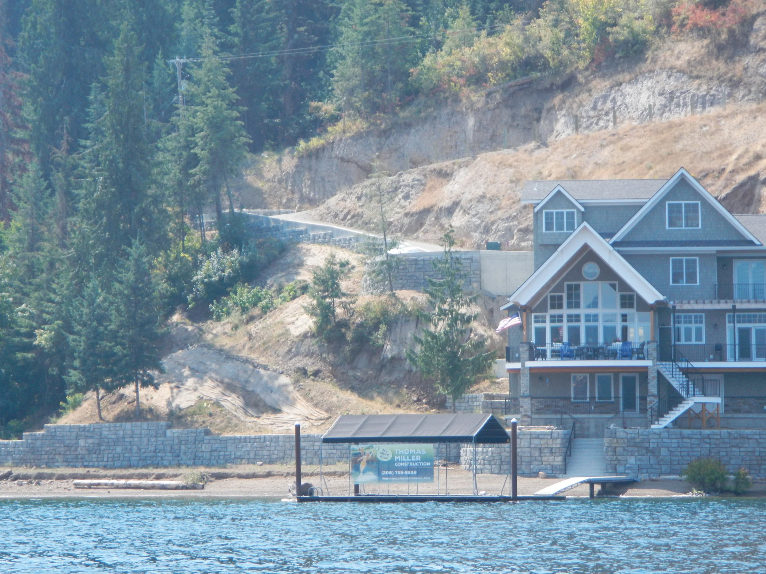
And then we began to see huge houses. Our boat pilot headed directly to a brand new, sprawling lakeside mansion on a steep hillside. We were a bit distracted as race boats whizzed by and parasails hovered above. But once this brand new development project was close enough to view, our collective jaws dropped at the potential for massive erosion caused by removal of native vegetation at this steep site.
The problems caused by lakeside development are many, but disruption of the phosphorus cycle is most concerning. Phosphorus pollution flowing into Lake Coeur d'Alene has greatly increased since the 1990s. Phosphorus is a naturally-occurring mineral, found in soil and rocks. In a forested ecosystem, it is absorbed and constantly recycled by plants and soil microorganisms. Once vegetation and topsoil are removed, phosphorus reaches the lake water by erosion and runoff. In the water, it acts as a nutrient, increasing growth of aquatic plants. Interestingly, plants and plant parts can also be a source of phosphorus.
Phosphorus is readily taken up by aquatic invasive weedy species. When the plants die off in the fall, oxygen is removed from the water during the decomposition process. When this happens, oxygen is no longer available for fish and other aquatic life that depend on it. Excess growth of these plants also blocks available sunlight to bottom-dwelling species, and this combination of processes speeds the problem of Lake Eutrophication.
Eutrophication, or hypertrophication, is when a body of water becomes overly enriched with minerals and nutrients that induce excessive growth of plants and algae. This process may result in oxygen depletion of the water body.
The Coeur d’Alene Tribe and the Idaho Department of Environmental Quality (DEQ) are working together to quantify how nutrients are getting into the lake. Streamside erosion, upland development, timber harvesting, urban stormwater, wastewater discharges, septic tanks, and agricultural practices are some of the contributors.

Our next stop was in front of this place with a massive lawn and hardened shoreline. Although plenty green and not an erosion source, this type of lakeside development can cause a host of problems that will speed eutrophication. If fertilizers and pesticides are not precisely applied, they will end up in the water.
Shorelines hardened with bulkheads, seawalls, rocks, riprap, and other structures to protect against erosion have the potential to adversely affect water quality. By manipulating the shoreline, removing native species, adding sand and other features, shoreline processes are altered, and ecologically valuable habitat is altered. In addition to shoreline disruptions, there are reportedly over 50,000 golf balls in the water in this area!

Healthy lakeside riparian vegetation looks like this (photo courtesy of Coeur d’Alene Tribe). Multi-layered native vegetation helps water quality by absorbing and softening rain, preventing erosion, filtering runoff, and providing important habitat for insects and wildlife. We noticed that most of the newer, larger homes preserved no native vegetation along the lake. Instead, many sandy beaches have been installed, which are not a natural feature. Unfortunately, only 25% of Lake Coeur d’Alene’s shoreline vegetation remains undisturbed. This loss is contributing to warming waters, increasing erosion, and phosphorus loading in the lake.

What we don’t see: The biggest problem of all is invisible. The lake is a repository for 75 million tons of sediment polluted with lead, cadmium, arsenic and zinc. In the early days of mining, tailings were deposited directly into the south fork of the Coeur d’Alene River. These metals have washed downstream after more than a century of mining in Idaho's Silver Valley. Today, the Bunker Hill Superfund Site is the nation's second largest Superfund site. The pollution from Bunker Hill and other mines in the Silver Valley extends both upstream and downstream from the 21-square mile "box" that is now included within the Superfund cleanup site. Due to the Clean Water Act and because mining operations have become more efficient, much less pollution is being deposited than in the past. But because of the huge amount of mine tailings in the Silver Valley, the toxic legacy will be with us for many years to come, likely forever.
The toxic metals are sequestered at or near the bottom of the lake. If oxygen levels are high enough, metals remain trapped in this area, because the sediments act as a sink for metals. This is where the decrease in oxygen is concerning: as oxygen levels near the bottom of the lake decrease, the solubility of metals in the lake’s sediment are affected, releasing metals into the water column. For this reason, the overall goal is to try to maintain the lake in a low-nutrient status, with high levels of oxygen in the lake's bottom waters.
The Good: The good is that this is a beautiful lake, and lots of folks are working to protect it. Right after the boat tour, I found a great hiking trail and swimming beach along Tubb’s Hill. The swimming was fantastic – I highly recommend it!
How to learn more and stay involved:
Here are a few links that offer great information about management of the Lake:
Idaho Department of Environmental Quality - Coeur d'Alene Lake Management
Coeur d'Alene Tribe - Lake Management Website
Kootenai Environmental Alliance/ Lake Coeur d'Alene Waterkeeper