

Summer 2018 Spokane River Water Temperature Study
Jule Schultz
Spokane Riverkeeper
November 2018

Abstract
The Spokane Riverkeeper monitored water temperature in the Spokane River in summer of 2018. Water temperature in the Spokane River showed the usual pattern of high temperatures approaching a daily maximum of 80 degrees or more in the losing reach at Barker Road and Harvard Road. The gaining reach continued to show water temperatures, under the state standard for interior redband trout of 64.4 F. Water temperature in the gaining reach continued to show decreased water temperature with decreasing flows in the Spokane River. Water temperatures in the Spokane River’s losing reach appear to be rising when compared to 2001 and 2002 data.
Introduction
The Spokane River runs 111 miles from Lake Coeur d’Alene to the Columbia River at Lake Roosevelt. Much of the River’s water is snowmelt that flows into Lake Coeur d’Alene by way of the Coeur d’Alene and St. Joe Rivers. The Spokane Valley-Rathdrum Prairie Aquifer also flows into the Spokane River, and makes up the majority of the flow into the river during low flow times of the year, such as late summer. The aquifer merges into the River near the Spokane-Spokane Valley line (downstream of Sullivan Road) and provides cool water (~12C) to the River. Above Sullivan Road, the River is fed by only surface water from Lake Coeur d’Alene, which can exceed Washington State water temperature standards during warm summers.
It is important to document temperatures in the Spokane River for native species protection and complete understanding of how climate change affects our river. Redband trout, the iconic species of the Spokane River, suffer stress when exposed to water temperatures over 18 C. Changing climate in the form of increasing air temperatures and earlier snow melt can also impact temperatures in the Spokane River, impacting trout habitat and possibly survival.
Methods
This study measured the water temperature of the Spokane River throughout the summer months (~July-September). Temperature loggers were placed in the River from the State Line to TJ Meenach Bridge at 11 locations, with replicates at four of those locations (See Figure 2 and Table 1).
Loggers were zip-tied to cinder blocks inside of a PVC shade (see Figure 1) and placed on the bottom of the Spokane River. Loggers at State Line, Harvard Road, and Barker Road were placed in aluminum cans to better hide them from snorkelers. This design helps to prevent theft and the loggers washing away, and shades the loggers. Loggers will be placed within 10 feet of shore to aid in retrieval. Even so, unfortunately, loggers at State Line and Barker Road were stolen.
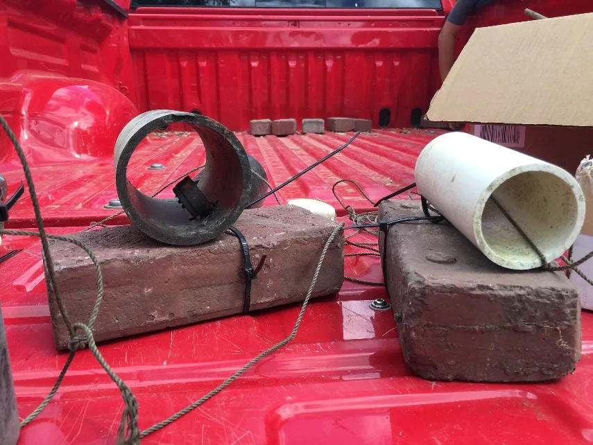
Figure 1. Temperature logger setup including PVC shade and brick weight
Loggers were placed in the Spokane River when water levels receded to a safe flow, usually under 3,000 cubic feet per second (cfs). This year, this happened on July 8th. Loggers were removed the week before Labor Day. Water levels rise after Labor Day to levels unsafe for retrieval. Loggers at Barker and Harvard Roads were downloaded midway through the study in order to share the information with WDFW.
Data from Upriver Dam site wasn’t used because the loggers were found floating.

Figure 2 Location of water temperature loggers in the Spokane River for summer 2018

Results and Discussion: Water Temperature in the Spokane River showed the familiar pattern of warmer summertime water temperatures in the losing reach upstream of Sullivan Road, with cooler water found downstream of Sullivan Road (gaining reach)(Figure 3). The difference was stark. Almost all temperatures in the losing reach (Barker, Harvard) were above 70 F, averaging 75 F (Table 2). Water temperatures downstream of Sullivan Road (Islands, Division St., TJ Meenach) remained below 64 F, averaging below 60 F (Table 2). These differences are due to the influence of cold aquifer water entering the Spokane River downstream of Sullivan Road.
The influence of changing Spokane River flows is apparent in water temperature data downstream of Sullivan Road. Islands Trailhead had both the warmest and coolest water temperatures downstream of Sullivan Road, reaching 66.2 F in early July and 52.4 F in late August (Figure 3). Water temperature at all locations downstream of Sullivan Road dropped on 7/20/18. This is most likely due to the effect of the reduction in flow of the Spokane River (Figure 5). The lower proportion of warm surface water to cool aquifer water cools the water temperature in this reach dramatically. The slight drop in water temperature at all locations on 8/10/18 and further drop on 8/20/18 were likely the result of lower air temperatures (Figure 4).
Water temperature in the losing reach of the Spokane River showed persistent temperatures above the state maximum of 64.4 F, which was implemented to protect native redband trout. The losing reach of the Spokane River contained water temperatures which averaged approximately 75 F, with a daily maximum of 81.6 at Barker Road in early August. Water temperatures remained in the 75-80 F range for much of late July and early August. Water temperature dropped to nearly 70 F on 8/20, likely the result of lower air temperatures.

Figure 3. Spokane River Water Temperature
The Barker Road location was slightly warmer than the Harvard Road location, most likely due to its location four miles farther downstream. Water has more time to warm up while in the river. Temperature differences downstream of Sullivan Road show a similar pattern, with the TJ Meenach logger showing the warmest data and being the farthest downstream.

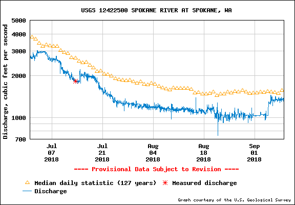
Figure 4. Spokane River at Spokane flow data during summer 2018
These data show the persistent warm temperatures in the gaining reach. These temperatures are much too warm for native redband trout, which seek cooler water downstream of Sullivan Road in the summer months. There is evidence that water temperatures in the Spokane River are rising. Average water temperature data taken from Stateline and Post Falls Dam in 2001 and 2002 by the Washington State Department of Ecology and United States Geological Service show cooler temperatures than those the Riverkeeper took in 2015, 2017, and 2018. Data in 2016 were similar to 2001 and 2002, statistically. The Riverkeeper continues to compile historic water temperature data from the Spokane River and will report the findings once collected.

Figure 5. Spokane air temperature data during summer 2018.

Figure 6. Daily average water temperatures in the losing reach during 2001, 2002, and 2015-2018.