
As protectors and stewards of the Spokane River, we have been monitoring this year’s snowpack closely. Mountain snowpack is the river’s “bank account.” Normally, snow stores water through the winter and then melts slowly over spring and summer, sustaining flows, fish habitat, recreation, and drinking water supplies. This winter the mountain snowpack has remained low, and broader climate patterns are stacking the odds against us.
A Winter of Low Snow and Warm Rain
This winter began unusually warm and wet. Instead of accumulating as snow in the mountains, much of our precipitation fell as rain. In December, river flows peaked at 5 times the median flow. That sent water rushing through the system early, raising winter flows temporarily but doing nothing to sustain the river into summer. By February, flows almost returned to normal, but we were instead following trends toward record low snowpack.
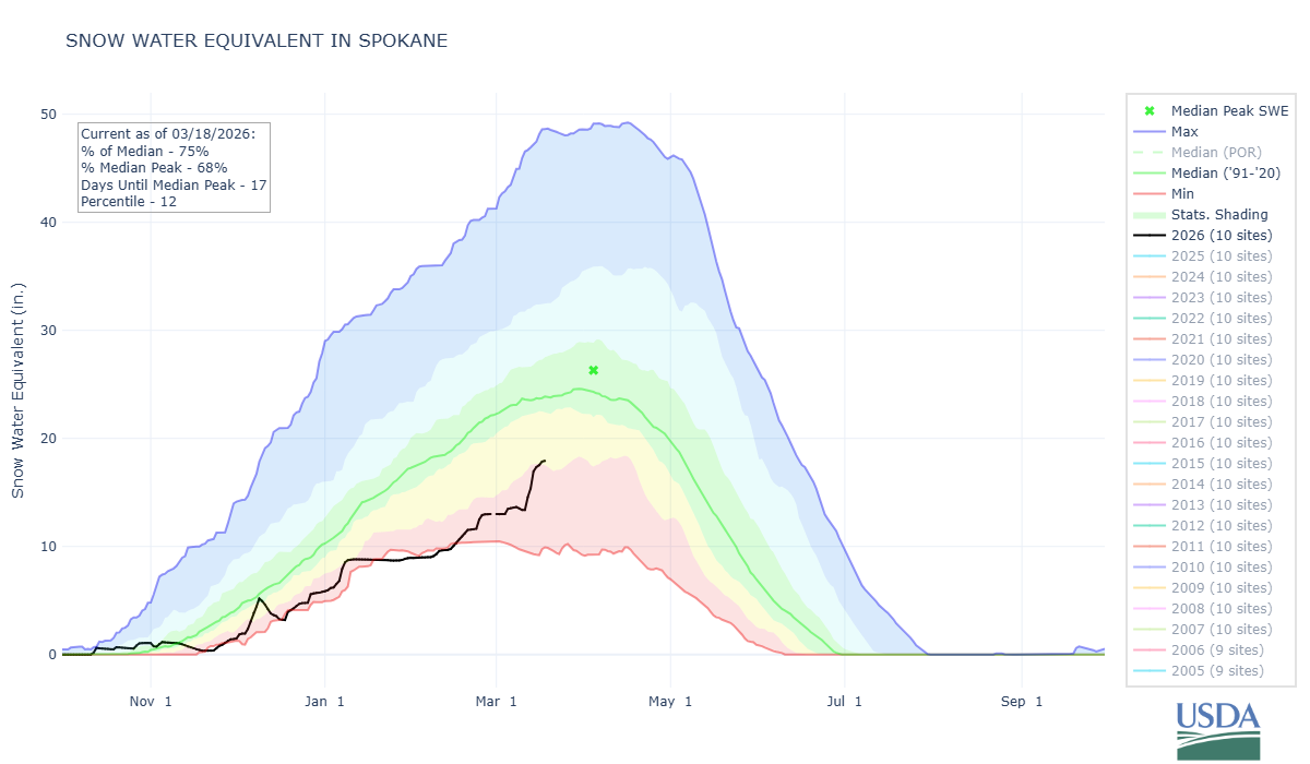
SNOTEL data, showing the current year’s snow-water equivalent in comparison to historical averages.
As of mid-March, we’re no longer looking at record lows and snowpack across the Spokane River Basin sits around 75% of average, boosted by a recent mountain storm. That sounds okay, but it masks a deeper problem: warmer temperatures are melting lowland snow almost as soon as it falls, and much of the water that could have brought the high spring flows is already gone.
The water year, which runs from October through September, is roughly halfway over, and the Spokane River is entering a critical period. So far, cumulative precipitation across the basin is actually above average, with SNOTEL data showing about 108% of the long-term median. That rainfall helped keep February streamflows slightly higher than normal throughout the basin. But the snowpack that normally sustains late spring and summer flows is far below average, with basin-wide snow depth sitting at just 48% of median. Even higher elevation stations show deficits: Lookout measured 36 inches of snow (53% of median), Kellogg Peak 24 inches (34% of median), and Fourth of July Summit just 6 inches (20% of median).
In practical terms, this means much of the water that should feed the river later in the season is already in the river and leaving the system, and forecasted flows for the spring and summer are expected to drop below normal. When precipitation comes largely as rain and snowpack is shallow at mid-year, rivers face extreme low flows later in the season, stressing fish, recreation, and water quality.
Why ENSO Patterns Matter
Global climate patterns in the Pacific Ocean, known as the El Niño-Southern Oscillation (ENSO), influence both the timing and type of precipitation. Currently, we’re in La Niña conditions, but forecasters warn of a potential El Niño later this year, with a 62% chance of formation by fall (Bellingham Herald, 2026). NOAA notes that during typical El Niño events, the Pacific Northwest often sees drier-than-average conditions. The strength of the El Niño matters: a strong event could exacerbate low flows and warm temperatures here, whereas a weaker one would have a less pronounced impact (NOAA, 2026).
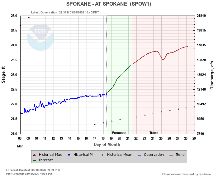
NW River Prediction Center flow predictions for the Spokane River indicate a rising trend.
When combined with already low snowpack and early spring warmth, the Spokane River faces extreme stress. Forecasts suggest that peak flows may arrive earlier in spring, late-summer flows may drop well below average, and river temperatures are likely to rise. These conditions can push sensitive fish species like redband trout toward lethal thresholds, increase nutrient and pollutant concentrations, and dramatically reduce recreational access.
What This Means for the Spokane River
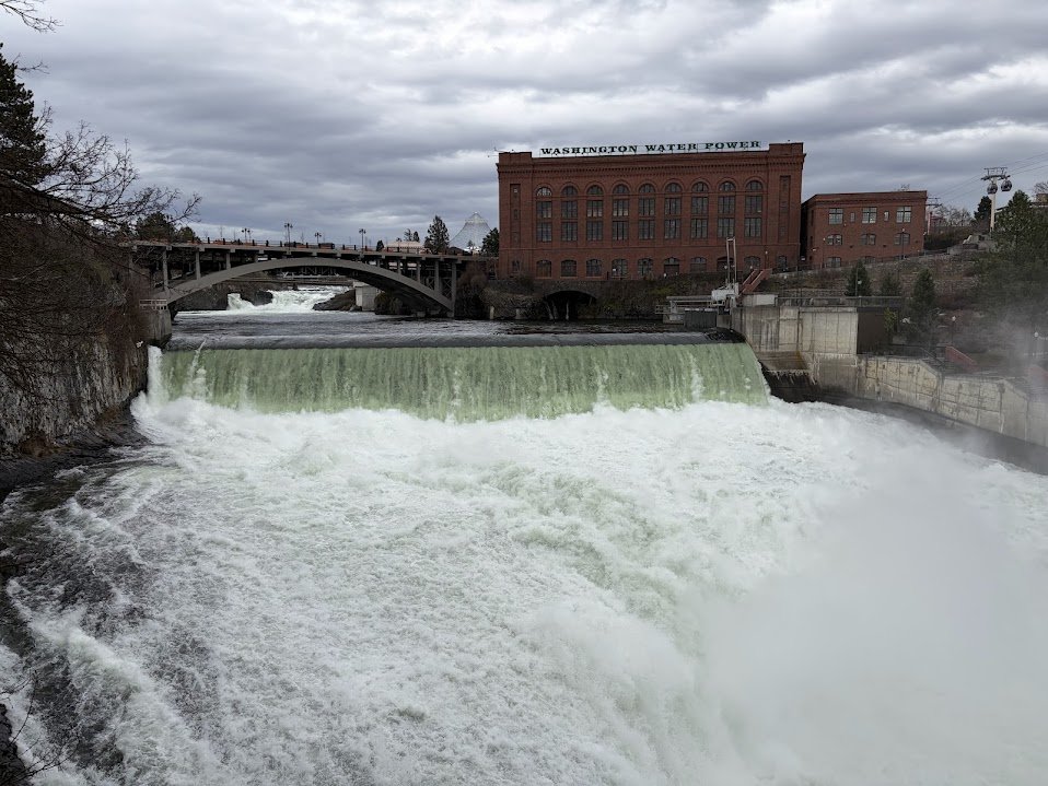
Spokane Falls lower falls, March 18, 2026.
Low snowpack and early snowmelt are already shifting the river’s natural rhythm. Peak flows in spring arrive earlier than historically, while late-summer flows dwindle far below historical averages. Warmer air and water temperatures amplify stress on aquatic life, making even short heatwaves dangerous for sensitive species like redband trout. Native salmon and trout may struggle to survive the hottest weeks of summer, while nutrient and pollutant concentrations rise as the river’s volume drops. Recreation and river access may become limited, disrupting local tourism and community activities that depend on reliable flows.
Spokane Climate Project data show that when spring flows peak early and summer flows are low, thermal stress for fish coincides with the period most critical for salmon spawning and juvenile survival. Local studies also indicate that even small drops in river volume can reduce aquifer recharge, affecting drinking water supplies. In short, the river’s resilience is diminished, and the impacts are felt throughout the ecosystem and community.
The next few weeks are critical. While mountain snowpack received a temporary boost from recent storms, the timing of snowmelt and spring temperatures will determine whether the river can make it through summer. If El Niño develops as expected, late summer flows could drop far below average, creating extreme conditions for the river and the communities that rely on it. And bring yet another summer with a dry stretch of river. Whitewater rafting, kayaking, and fishing may be disrupted or shortened, while local ecosystems face thermal and flow stress that threatens biodiversity.
Looking Ahead
We’ll be tracking river flows and water temperatures regularly, monitoring snowpack conditions, and updating our community about risks. Our goal is to educate and equip residents, anglers, and policymakers to respond sooner rather than later, because low-flow, high-temperature summers are becoming the new normal under climate change.
Understanding the science of snow, runoff, water-year progression, and climate patterns isn’t abstract—it’s essential to protecting the Spokane River. The river’s health this summer depends on both the snow we’ve already lost and the climate patterns shaping what comes next.
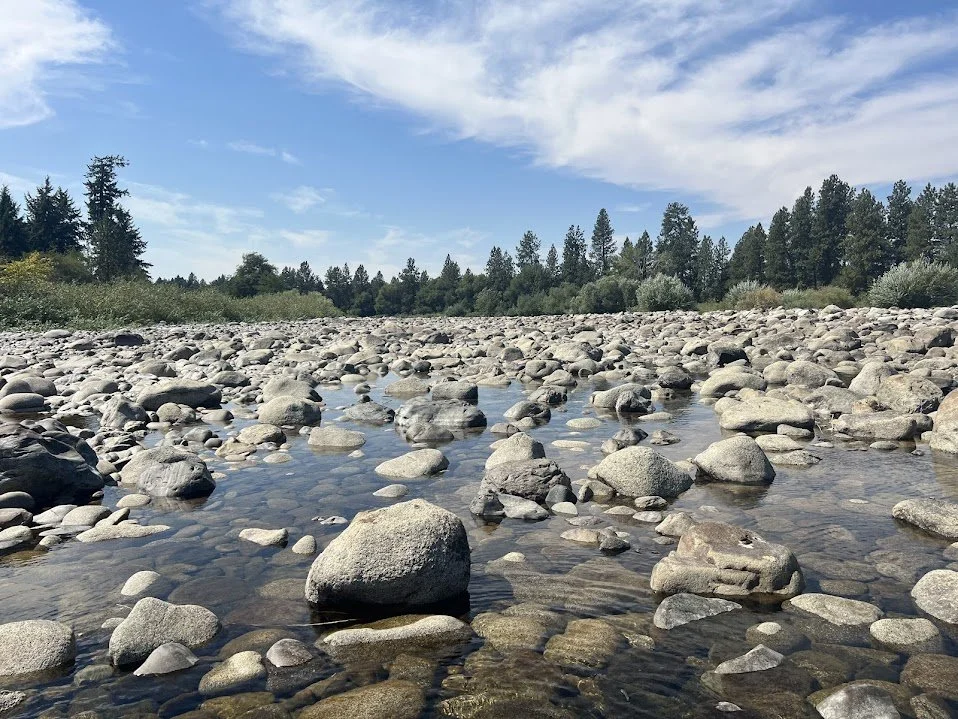
Spokane River near Barker Road, August 2025,
Sources
Spokane Climate Project (2019)
BBC News Climate & Science (2026), “What are El Niño and La Niña, and how do they change the weather?”
Bellingham Herald (March 16, 2026), Robert Mittendorf, “There’s an El Niño watch. Here’s how it could affect Western Washington weather”
NOAA, CIRES/NOAA/NIDIS (March 11, 2026), Joel Lisonbee, “El Niño on the Horizon: Can the Warm Phase End Six Years of Drought in the Southern Plains of the U.S.?”
SNOTEL (2026), U.S. Department of Agriculture Natural Resources Conservation Service, Snow Telemetry (SNOTEL) Network Data