
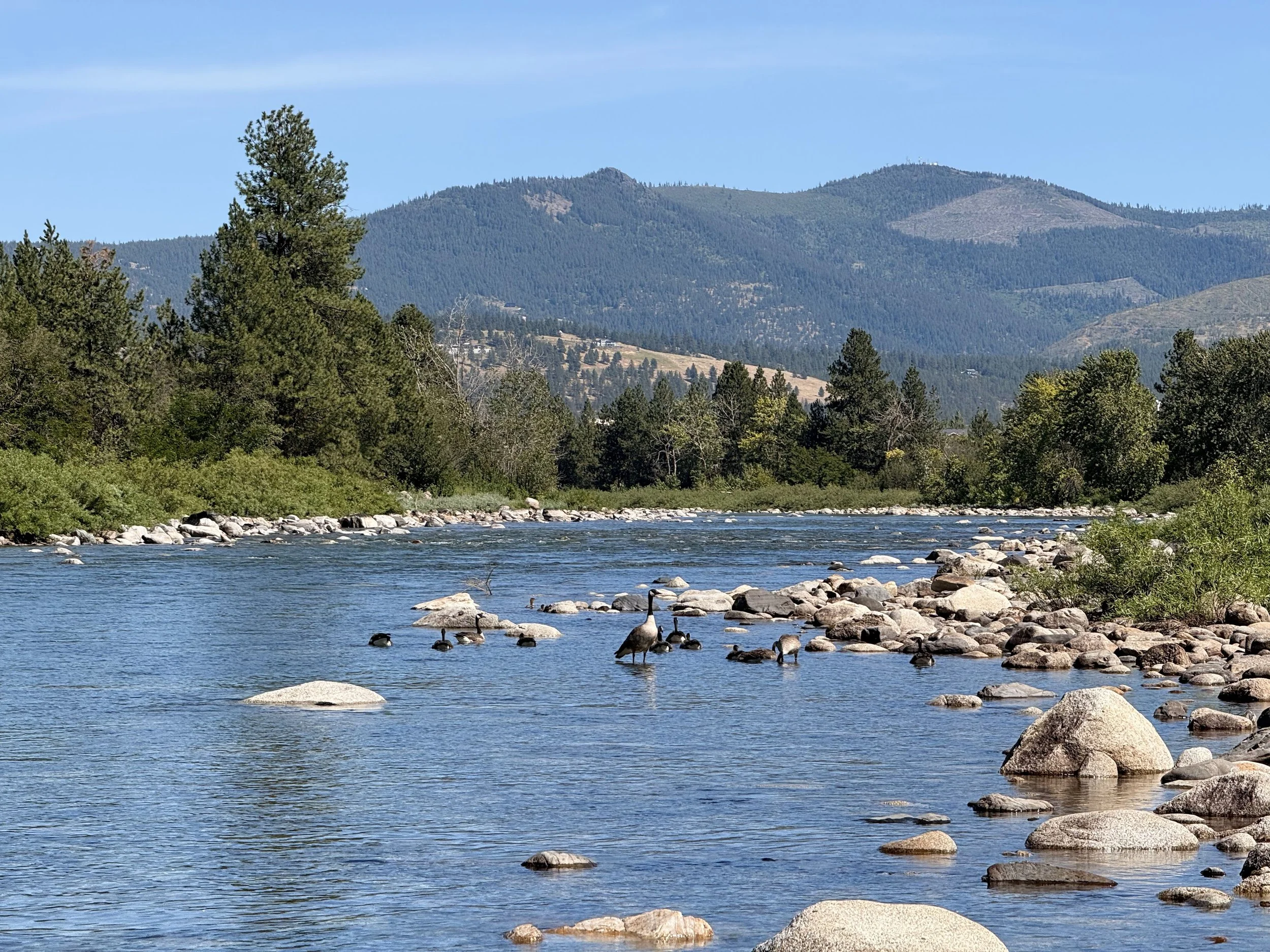
The dog days of summer have arrived, bringing the heat, dry weather, and long summer days.
The phrase comes from an old story written in the stars. Ancient Greeks and Romans noticed that the hottest days of the year arrived around the time Sirius, the brightest star in the constellation Canis Major, also known as the “Dog Star”, appeared in the sky. They believed the star added to the sun’s heat and helped bring the sweltering days of summer.
Of course, we now know Sirius is not responsible for the temperature climbing into the 90s. But the phrase has endured because it captures something we all recognize: that long, hot stretch of summer when the days feel endless, the heat settles in, and everything begins to slow down.
For the Spokane River, however, the dog days are not a time of slowing down. They are a time of angst and dropping flows.
The mountain snowpack that stored water through the winter has already melted and moved through the watershed. Now, as we settle into the heart of summer, the Spokane River depends more heavily on the hidden parts of its system: groundwater, managed releases from Coeur d’Alene Lake, summer precipitation, and the choices we make about how we use water.
This is also when the Spokane River’s hidden connections become easier to see. A person standing at Spokane Falls, looking at the water rushing through Riverfront Park, is seeing one part of a much larger story. Someone standing near stateline, or even further upstream above Post Falls, will paint a much different picture. Between those places, the river is constantly exchanging water with the landscape around it, losing water into the aquifer in some places, gaining water in others.
During the dog days of summer, those differences become impossible to ignore
Gauge Conditions
One of the easiest ways to see these differences is by looking at the river’s gauges. Each gauge tells a different part of the story because each one captures the river after it has interacted with different parts of the watershed. The Post Falls gauge sits just below Post Falls Dam in Idaho. The Spokane gauge sits nearly 25 miles downstream past downtown Spokane, after the river has traveled through most of the urban environment.
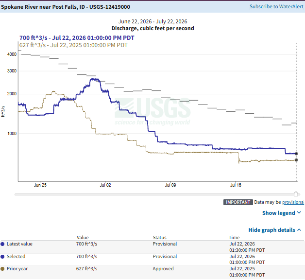
Upstream near Post Falls, as of July 22, the river is flowing at 700 cfs, compared to 620 cfs on the same day last year. This gauge tells a different part of the story, one closely tied to Coeur d’Alene Lake and the operation of Post Falls Dam.
During the summer, Avista gradually reduces releases from Post Falls as the system transitions into the low-flow season. Under Avista’s FERC license, releases are maintained at a minimum of 600 cfs from June 7 until the Tuesday following Labor Day to support wild rainbow trout habitat downstream of the dam. During particularly low-water years, releases can be reduced to 500 cfs if lake levels fall below the established threshold.
The timing of those reductions gives us one clue about summer river conditions, but it does not tell the whole story. The last few summers show why.
In 2025, Post Falls releases reached the 600 cfs range on July 15 and dropped to 500 cfs on August 6. By late August, a stretch of the Spokane River near Barker Road went completely dry for nearly a mile and a half. In 2024, the transition happened later. Post Falls reached the 600 cfs range on July 17 and did not reach 500 cfs until August 21. The river remained connected throughout the summer.
Looking back at recent low-flow years, in 2015 (the lowest-flow year in recent history) Post Falls reached the 600 cfs range much earlier, on June 1, and dropped to 500 cfs by July 22. Despite those early reductions, the river maintained continuous surface connection the whole summer.
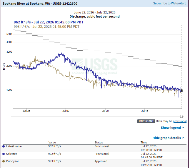
Meanwhile, downstream at the Spokane gauge, as of July 22, 2026, the river is flowing at 952 cubic feet per second (cfs). That is slightly higher than the 908 cfs measured on the same day last year, and over 200 cfs higher than Post Falls. Going back to 2015 again, the Spokane gauge was even lower, with flows of just 836 cfs at this point in the summer (over 300 cfs higher than it was at Post Falls that same day, dropping to near 700 cfs over the following week).
The Hidden Driver: the aquifer
The differences we see across the watershed and throughout time help us understand that surface inputs from Lake Coeur d’Alene are only a portion of the flows. What happens between Post Falls and Spokane matters too, if not even more than what’s coming over the dam.
As the river travels downstream, it interacts with one of the most important parts of our regional water system: the Spokane Valley-Rathdrum Prairie Aquifer. The river and the aquifer are intricately connected, constantly exchanging water. In some places, the river loses water into the aquifer. In others, groundwater returns water to the river and helps sustain flows.

During the summer, when snowmelt is gone and rainfall is limited, those underground connections become increasingly important. And that connection is also why summer water use matters. The aquifer is the sole source of drinking water for much of our region, but it also plays a role in maintaining Spokane River flows, as well as ensuring safe water temperatures for redband trout. When more water is pumped from the aquifer during the hottest and driest part of the year, less water is available to support the river and its inhabitants.
It is estimated that summer pumping reduces Spokane River flows by approximately 120 to 175 cfs. During high-flow months, that change may be difficult to notice, but during the dog days of summer, when the river is already operating near its lowest flows of the year, those losses become much more significant.
Washington’s Instream Flow Rule represents the state’s effort to protect the river from the impacts of increasing water use. The rule recognizes that the river has a need for water and establishes a legal water right for the Spokane River to help protect important resources like fish habitat, water quality, and recreation. From June 15- September 30 minimum flows are set at 850 cfs.
But a water right on paper does not always translate into water in the river. Like all water rights in the West, the Spokane River’s instream flow right is governed by the principle of “first in time, first in right.” The river’s instream flow was established in 2015. All water rights established before the instream flow rule have priority over the river’s right. When water gets low, newer (or junior) water rights get shut off to protect the older (senior) water rights. In our basin only one water right is junior to the river, and it is not in use yet. While the rule identifies the minimum water the river needs, it doesn’t simply override older rights when water becomes scarce.
That is where our choices matter. During the hottest and driest months of the year, when the river is already relying more heavily on groundwater and the more hidden parts of the system, reducing unnecessary water use helps protect the water that remains available for both our communities and the river.
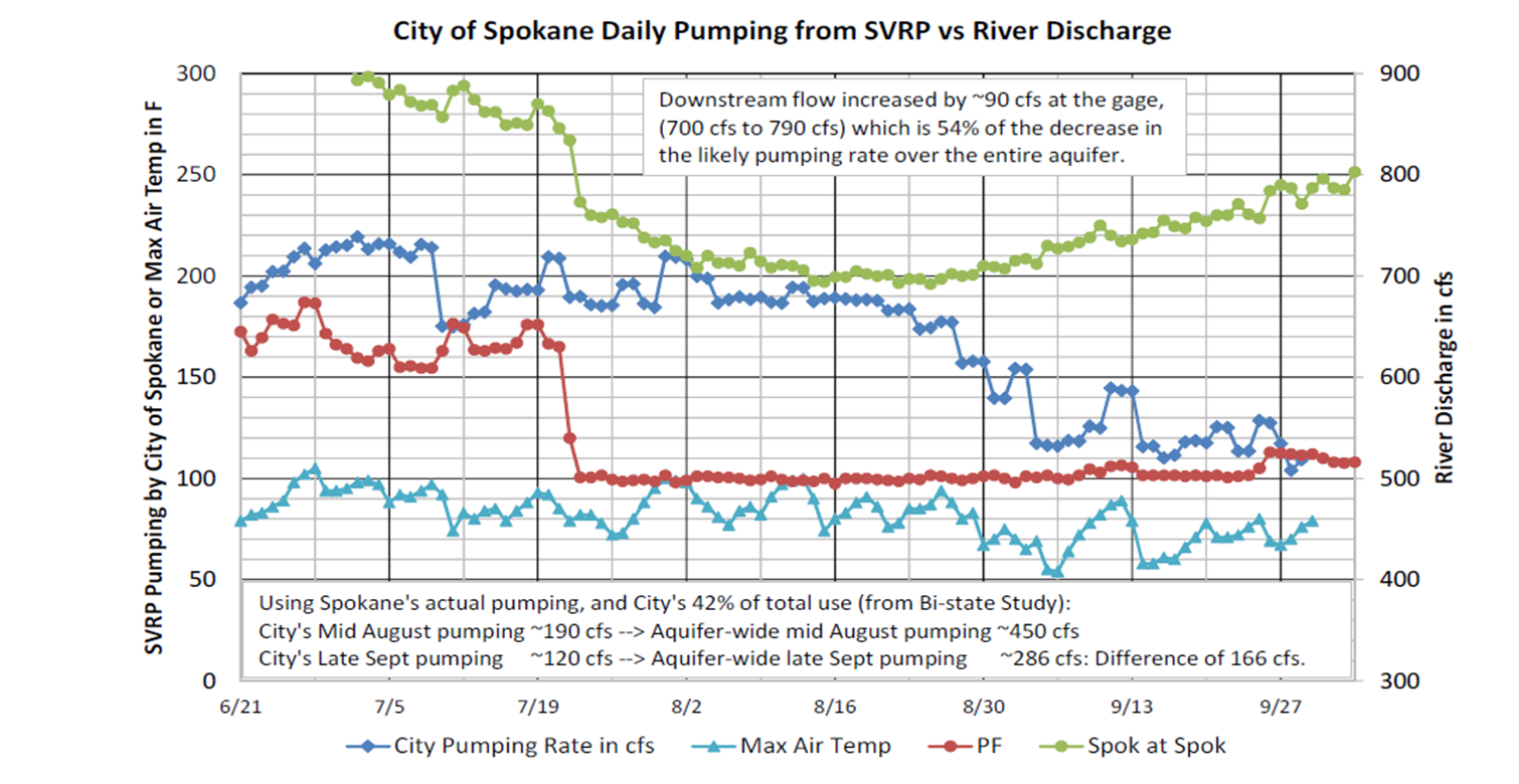
In this graph from 2015 you can see that river flows increase dramatically when city pumping slowed down, without any changes from upstream sources or rainwater input. The red line shows that flows over Post Falls Dam remained fairly consistent into September, yet the river flows are slowly increasing.
The future of the Spokane River will not be determined by one dam release, one gauge, or one regulation. It will depend on how we manage the entire connected system, and whether we choose to be active participants in protecting it.