October marks the start of a new water year, the calendar followed by water managers and water supply forecasters. As we head into a new water year, we’re looking back at what happened to the Spokane River in 2026 and what current forecasts suggest for the months ahead.
Looking back at 2026
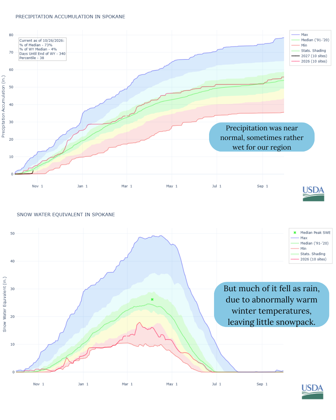
Last winter brought warm temperatures, low snowpack, and big rainstorms. Precipitation across the basin was near average (even above average at times), but much of it fell as rain instead of snow, even high in the mountains. That meant less water was stored in the snowpack to sustain the river through spring and summer.
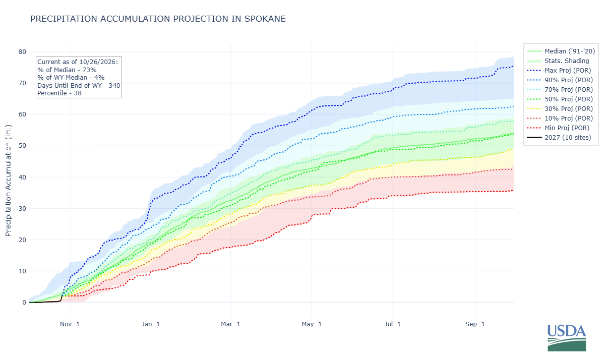
Source: USDA NRCS
The precipitation and snowpack graphs show two different parts of the story. Precipitation accumulation measures how much moisture the basin received, while snow water equivalent (SWE) estimates how much water was stored in the snow. Snowpack acts as the river’s long-term reservoir, historically melting off in the Spring and sustaining surface flows through summer.
By mid-March 2026, snowpack across the basin was around 75% of average, and snow depth was only about 48% of the median. Snow monitoring stations reached zero snow water equivalent on June 25, just one day later than the prior year and only a few days earlier than the 30 year median of June 28. So, while supply was low at the end of winter, it hung in there through spring.
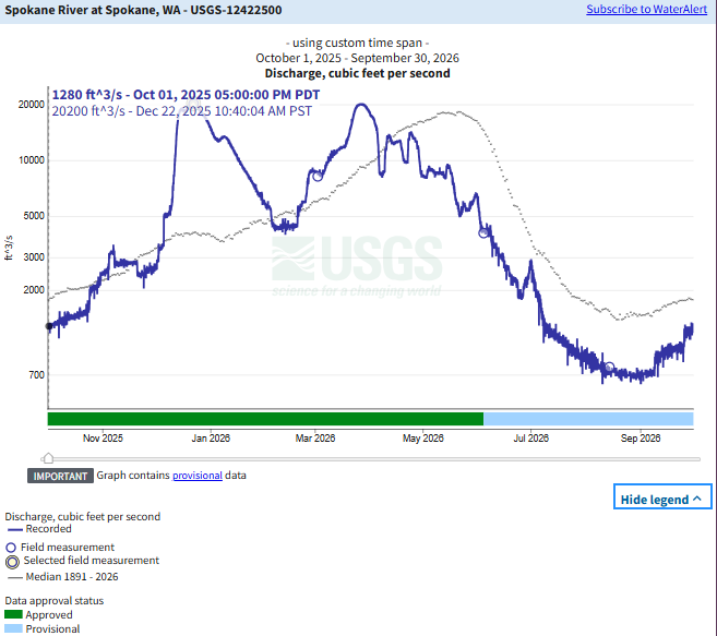
Still the river’s flow pattern also stood out. Flows at the Spokane gauge peaked in December during storms that caused flooding in North Idaho, then rose to a second, similar peak in April. Instead of one dominant seasonal peak, we saw two. This pattern is consistent with what we expect as winters warm and more precipitation falls as rain rather than snow.
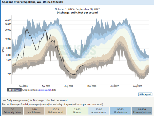
Source: USGS
After those peaks, flows dropped through the summer, reaching very low levels in August. From August 2 through Labor Day weekend, the Spokane gage was below the instream flow rule minimum flow of 850cfs.
For the full October 2025 through September 2026 water year, runoff at the Spokane gauge was 94% of normal. That might make the year look fairly typical. But from April through September, runoff was just 56% of normal, the 8th lowest total since records began in 1971.
We’ve been seeing a dryer summer for a few years now. April–September runoff was 54% of normal in 2024 and 61% in 2025. That marks three consecutive years with well-below-average runoff during these months. Near-average precipitation over a full year has not translated into enough water to sustain the river through summer.
As we enter the new water year, current flows at the Spokane gauge are also below average, similar to this time last year. The river’s condition today does not determine how the whole year will unfold, but it is an important starting point as we enter the wet season.
What could this water year bring?
The early outlooks give us reason to be concerned about the months ahead, though they do not point to one certain outcome.
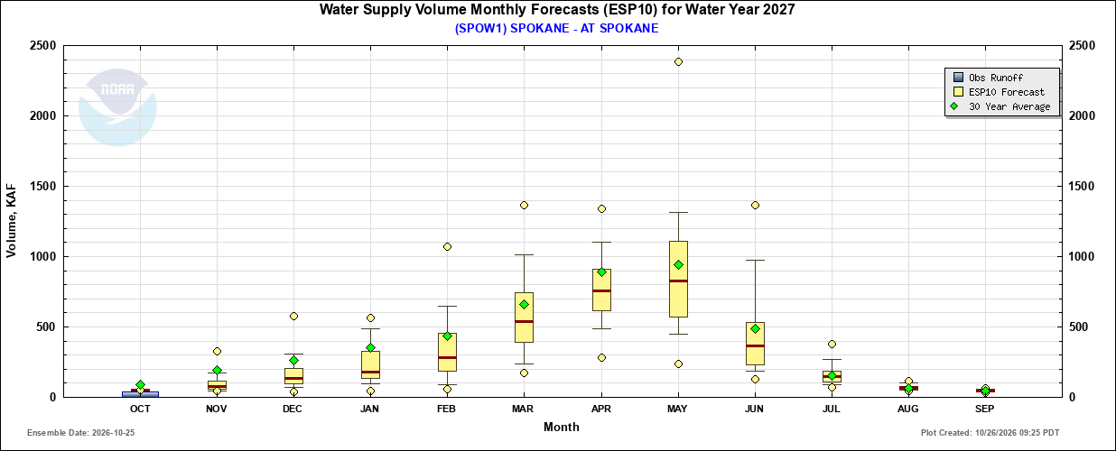
The Northwest River Forecast Center’s extended streamflow forecast now looks ahead through March. This forecast can’t predict what we will see next summer, but it is helpful for tracking how river flows may change over the coming months. The center’s seasonal water supply forecast looks further ahead, estimating how much runoff may reach the river during spring and summer. Its current median forecast for April through September is about 87% of the long-term average, with a wide range between the lower and higher scenarios. That is below average, similar to last year, but it's still early.
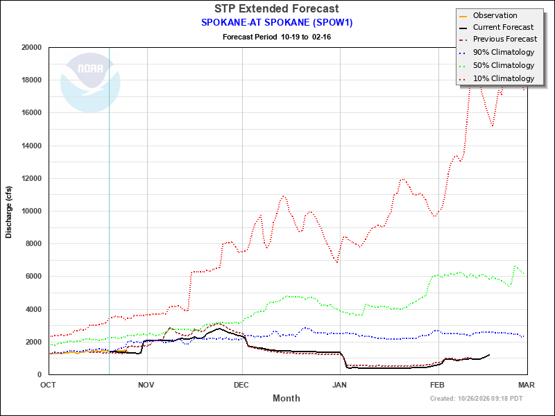
Source: Northwest River Forecast Center
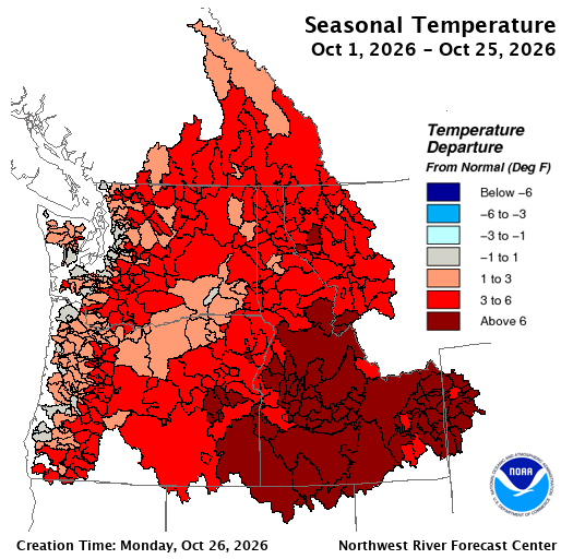
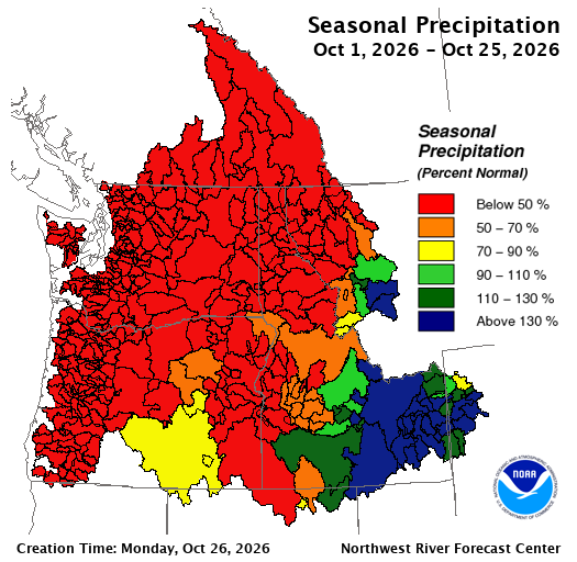
The climate outlooks add another reason for caution. NOAA’s November through January outlook favors above-normal temperatures across our region. The Spokane River watershed shows an increased chance of below-normal precipitation too. Warmer temperatures can mean more winter precipitation falls as rain and less accumulates as snow. If precipitation is also below normal, the basin could see low snowpack and have less water overall.
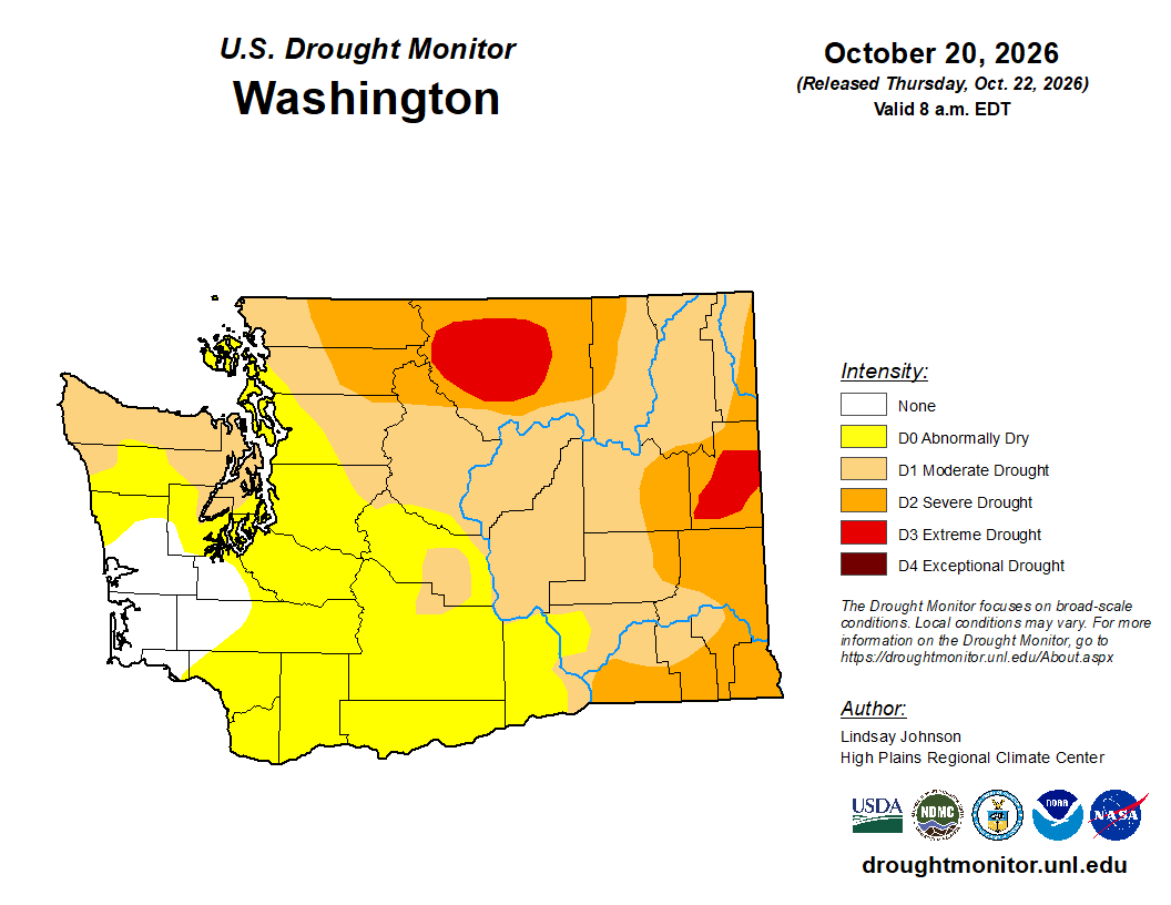
The region is also still experiencing severe drought conditions. Drought reflects more than just how much rain or snow falls in a given week. It can reflect accumulated shortages of moisture in soils, streams, and other parts of the watershed. The U.S. Drought Monitor provides a broader picture of those conditions, while local snowpack and streamflow data help us understand how they are affecting flows in the Spokane River.
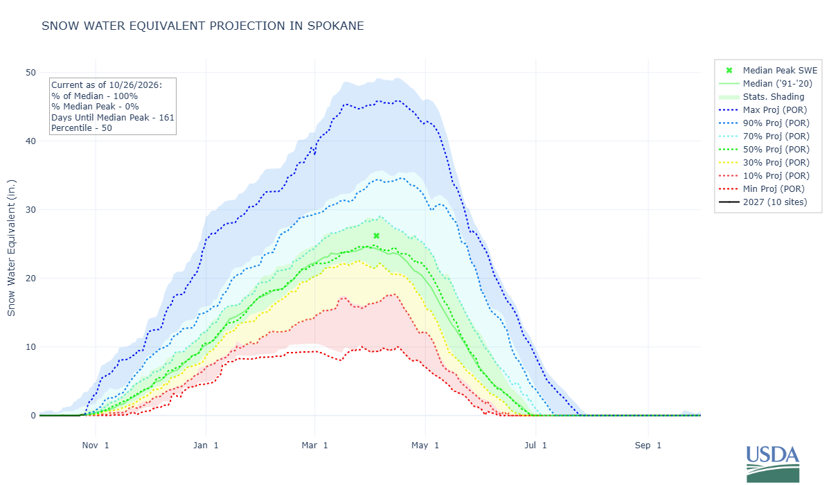
There is still a wide range of possible outcomes for the coming water year. Seasonal forecasts cannot tell us exactly how much precipitation we will receive, how much will fall as snow, or how the snowpack will develop through winter. The projections for full-year precipitation and snow water equivalent reflect that uncertainty. A wet stretch of weather could improve conditions, while a warm winter with limited snowfall could leave us facing another difficult summer.
We will need to see how the winter unfolds before we know what spring and summer might bring. The forecasts are concerning, but they are not a certainty. We will continue tracking snowpack, river flows, and updated forecasts as the water year progresses.
What about the dry reach?
The dry reach of the Spokane River, where surface water disappeared along a stretch of the river in both 2025 and 2026, is a related but distinct concern. Our seepage data indicate that the dry reach is likely to happen again this water year if Post Falls flows drop below 600 cfs. The seasonal forecasts do not tell us exactly when it will happen, how long it will last, or how it will compare to previous summers.
If drought and low water availability are major drivers of the dry reach, another year of below-average runoff would be concerning. The current outlook gives us reason to take that possibility seriously, even though it cannot tell us exactly what will happen.
Understanding how precipitation, snowpack, and river flows are changing is essential to protecting and restoring the Spokane River for future generations.
More graphs and resources
The graphs below provide additional context for the conditions described above.